


The research titled “Utilization of Mapping Technology to Improve Efficiency and Effectiveness in Public Facility Management in Panyingkiran Village, Panyingkiran Sub-district, Majalengka Regency” aligns with SDG Goal 11: making cities and human settlements inclusive, safe, resilient, and sustainable. This research was conducted by Ratih Fitria Putri, Sri Rum Giyarsih, Cicilia Hary Febryola, Wafiq Nur Azizah, Ridho Andutariansyah, and Lina Agustina Pujiwati. It also addressed one of the nation’s challenges—urban public facility management effectiveness.
This study was conducted in Majalengka Regency, one of the partners of Gadjah Mada University (UGM) in research and community service initiatives. The urgency of this research lies in its alignment with the themes of the National Research Priorities (PRN) and UGM’s own research priorities. The originality of the research lies in its focus on leveraging mapping technology to enhance the efficiency and effectiveness of urban public facility management.
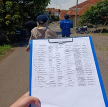
The objective of this research was to analyze the spatial distribution patterns of public facilities in the village to support community-based development planning. The data used include primary data collected with field observations and geolocation of public facilities, as well as secondary data in the form of administrative records from the village government.
The analysis was conducted using a quantitative descriptive approach combined with GIS-based spatial analysis to identify distribution patterns and disparities in access between different areas. The findings show that most public facilities in Panyingkiran Village are concentrated in densely populated areas, while several other regions have limited access to essential services such as healthcare and education. The research recommends optimizing existing facilities and developing new ones in areas with low accessibility and high potential social risk.
Author: Ratih Fitria Putri