• About UGM
  • Students Portal
  • Library
  • IT Center
  • UGM Mail
  • Informasi Publik
  • English
    • Bahasa Indonesia
    • English
Universitas Gadjah Mada THE GRADUATE SCHOOL OF
UNIVERSITAS GADJAH MADA
  • Home
  • About Us
    • About Us
    • Excellence
    • Status
    • Management Structure
    • Campus Life
    • Facilities and Services
    • Contact Us
  • Academics
    • Announcement
    • Academic Documents
    • Academic Calendar
  • Admission
    • Study Programs
    • Scholarships
    • Admission Requirements
    • How to Apply
    • Registration
  • Activities
    • Events
    • News
    • Research
    • Community Service
    • Universitas Gadjah Mada
  • Publication
  • Home
  • News
  • Geo Info Student Field Lecture: Studying Landslide Vulnerability in Kalisari, Magelang

Geo Info Student Field Lecture: Studying Landslide Vulnerability in Kalisari, Magelang

  • News
  • 5 May 2025, 15.32
  • Oleh: pudji_w
  • 0

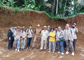
Geo-Information Interest for Disaster Management and Spatial Planning UGM Postgraduate School held a field lecture activity in Kalisari, Margoyoso, Salaman, Magelang on Saturday, April 26th 2025. This activity was attended by 7 students and 4 lecturers.

This Field Lecture is a form of implementation of the Module F Field and Studio Activities course. One of the objectives of the field lecture is providing students with an understanding of the landslide conditions that occurred in Kalisari.

Students were also given the opportunity to practice tools and drones for aerial photography data in the Kalisari, Margoyoso, Salaman, Magelang areas. This practice further increases students’ understanding of technological innovation’s use and its utilization for natural disasters, especially landslides.

Phisca Maulana Zaky is one of the Geo-Info students who participated in the activity. “In my opinion, the field activity on Saturday, April 26th 2025 in Kalisari Margoyoso Salaman Magelang can increase students’ knowledge in seeing landslide conditions in the area directly. Students are also taught to use tools that are commonly used for data collection, such as GPS and drones,” he said.

The material taught is also related to the social conditions of the community affected by the landslide in Kalisari, Margoyoso, Salaman, Magelang. Landslides in Kalisari can cause landslides to the residents’ rice fields, which are mostly rice plants and residents’ plantations such as bananas, cassava, and coconuts.

“Students can also observe the social conditions of the community in the area and examine the vulnerability to landslides in Kalisari.” he concluded.

Author: Siti Muyasaroh

Tags: SDG 13: Climate Action SDG 15: Life on Land SDG 4: Quality Education

Recent Posts

  • Consortium Meeting for JTTS Collaboration: Finalizing Research Findings for Sustainable Policy-Making in Sumatra
  • SPs UGM Strengthens Tridharma in Tourism: Doctoral Program in Tourism Studies Expands STO and Launches “Visitor Management” Book
  • Master’s and Doctoral Students of National Security Studies at UGM Graduate School Join Thesis and Dissertation Strengthening Bootcamp
  • Prof. Armaidy Armawi Presents Astropolitics and National Resilience at Senastindo VII AAU 2025
  • Population Studies PhD Program and BRIN Review Strategic Research Directions, Strengthen Collaboration in Research Partnerships
Universitas Gadjah Mada
THE GRADUATE SCHOOL OF
UNIVERSITAS GADJAH MADA
Jl. Teknika Utara, Pogung, Sinduadi, Mlati, Sleman, Yogyakarta, 55284
Telp. (0274) 544975, 564239
Email : sps@ugm.ac.id

© Universitas Gadjah Mada

KEBIJAKAN PRIVASI/PRIVACY POLICY

[EN] We use cookies to help our viewer get the best experience on our website. -- [ID] Kami menggunakan cookie untuk membantu pengunjung kami mendapatkan pengalaman terbaik di situs web kami.I Agree / Saya Setuju